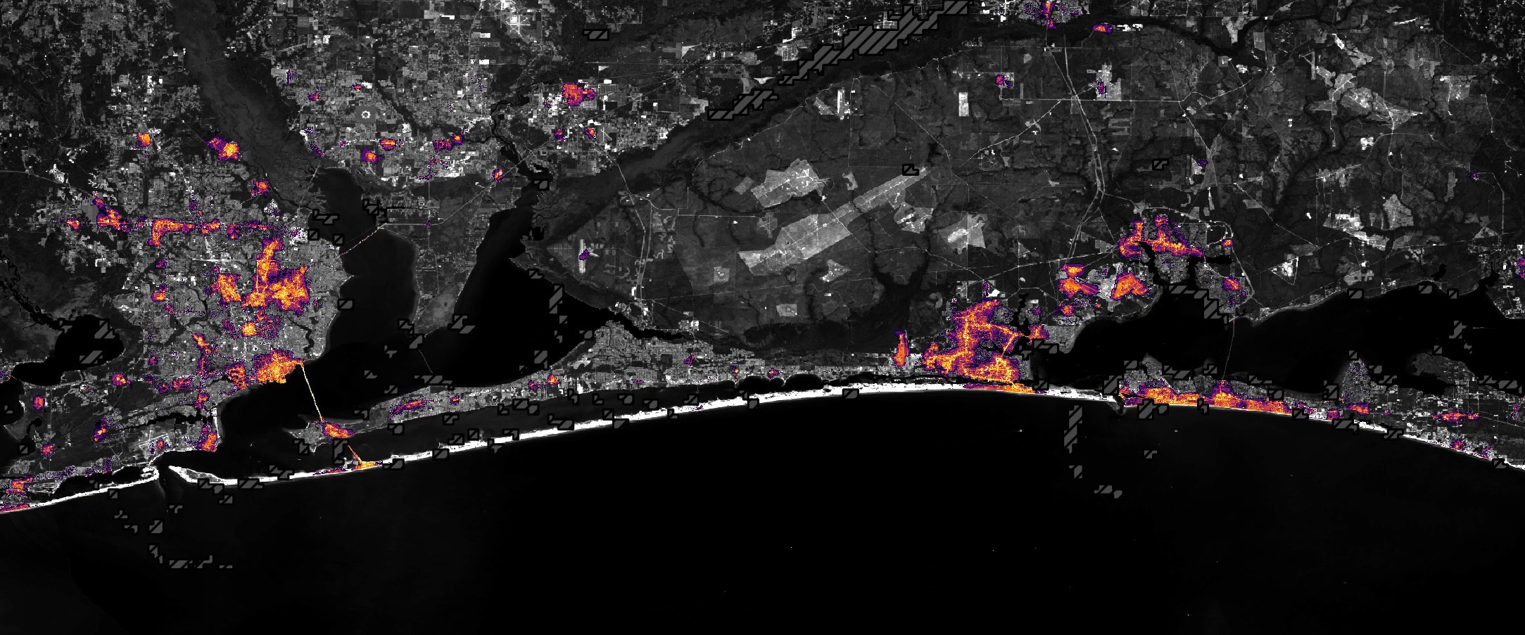
Satellite measurements show where lighting faded along Florida's Panhandle after Hurricane Isaias and where it later returned, according to an analysis NASA published October 16. The observations suggest extensive electricity disruptions around Pensacola and the road corridor running east toward Destin.
The agency compared an August baseline with measurements from October 11, after much of the storm's cloud cover had cleared. Lights were returning in some locations by October 12. By October 14, the overall lighting pattern resembled conditions before the hurricane, the agency reported.
The analysis follows Isaias' October 9 landfall near Destin as a Category 2 hurricane with sustained winds of 105 mph. NASA said the storm's wind and flooding affected parts of Alabama and the Florida Panhandle, with trees falling and power lines damaged.
The maps come from Black Marble HD, which processes nighttime observations from the VIIRS instrument on NOAA-20. A Landsat 9 base map supplies geographic context. Researchers adjust for atmospheric effects, changes on the ground and the Moon's phase, and filter illumination unrelated to electric lighting. Hatched areas indicate missing observations because of clouds, rather than confirmed outages.
Ranjay Shrestha, of the Black Marble science team, said the more detailed product reveals changes at finer scales than standard nighttime imagery. Some lights persisted around Pensacola's airport, Pensacola Christian College and parts of downtown.
Those bright spots do not establish why electricity remained available. Shrestha said backup systems, infrastructure differences or an uninterrupted supply were possible explanations, but images alone could not distinguish among them. Likewise, a return to the earlier lighting pattern is not a count of customers whose service was restored.
Shrestha said tracking places recovering or still disrupted can guide responders toward areas needing attention and help them assess restoration work. NASA describes the satellite data as a complement to reports collected on the ground, rather than a replacement.
NASA's Disasters Program is also coordinating with FEMA and the USGS Coastal Storms Team to support Alabama's Red Cross and emergency management agency. The program plans to add maps and data to its public portal as information becomes available.